- Yes
- No
Some airborne radars, irl, were not only capable of detection and track of moving surface targets, but also could produce images of the surface at various resolutions, being able to capture a clear view of the ground without weather, smoke and dust obstructing the view.
The weather is becoming more and more a hazard capable of nullifying every CAS, with clouds blocking thermal imagers and fog blinding aircraft that don’t have said FLIRs.
The search radars on the helis are disgusting, though they can detect stationary ground targets, they don’t identify what is being seen.
There are, already, aircraft that posses such capability of producing radar imagery in game: From the helicopters, I don’t have info about it on the Mi-8AMTSh-VN’s VN001 and on the AH-64D’s AN/APG-78, though I’m sure that if they have STI, they will have ground mapping modes.
Mi-28NM’s N-025
http://www.xliby.ru/transport_i_aviacija/vzlyot_2008_05/p9.php
Ka-52’s Arbalet
Rosoboronexport page 103

For the planes already in game, the ones I have info are:
F-15E’s AN/APG-70
https://www.forecastinternational.com/archive/disp_pdf.cfm?DACH_RECNO=729
Pages 2 and 3
The APG-70 Radar Simulation Model.
A simulation of the AN/APG-70 ground mapping capabilities.
Su-39’s Kopyo-25
Rosoboronexport page 102

MiG-21 bison’s Kopyo-21

Typhoon’s Captor-M
Su-24M’ Orion-A: a topic by overscann mentioning mapping modes for the Orion-A and a documentary where at 5:38 a radar display shows a Real Beam Map updated with each radar sweep.
Sukhoi Su-24 Avionics | Secret Projects Forum
Neba: Sukhoi Su-24 documentary part 1/2
I found a mention of the Su-34’s leninetz V004 capable of detecting bridges. Unless it has a Stationary Target Indicator, sure this means capability of using ground mapping to find fixed targets.
I found a video and a article mentioning ground mapping capabilities on the Tornado IDS. This probably is valid to all but the ADV version, which has a different radar in game:
The section of the video that mention the specific scope and ground mapping is 19:15

MiG-29SMT’s Zhuk-ME:
rosoboronexport catalogue page 100

I couldn’t find more info, but I’m sure aircraft like the Rafale have ground mapping capabilities along with the A-G modes on the radar.
How it should be in game?
You would press the keybind for changing radar mode, till one of the PPI or SAR modes are shown. When one of these modes is selected, what firstly will be shown is the RBM of the ground, which is updated in each sweep of the antenna. The target cue selector also would appear and the elevation of the antenna has to be manually controlled, just like if these options where activated for usual radar modes.
When pressing the keybind to track a target, the radar will keep its elevation and azimuth orientation both locked and will scan the same area until it produces a image of the type of the mode selected(SAR or PPI). If the aircraft maneuvers makes the radar goes past the gymbal limits of the antenna or if the track target keybind is pressed again, it will abort operation and will commence the RBM again.
A successful PPI or SAR map will put the radar scanning on hold and the image produced will stay on the radar display, frozen; a special keybind should exist, for zoom in and zoom out of the map, be it RBM, PPI or SAR.
In the ground mapping modes, the cue target selector serves as marker to guide the aiming sights, meaning where it is pointing in the ground map in the radar display, the TGP will also point there. The same considering the PPI or SAR maps: if the aircraft turns cold but hold the map produced freezed, it can mark it using the target cue selector just like the function to put the target mark using the map. This warrants another keybind: one for fixing the cue target selector, which makes it track the point in the map and slaves the TGP to the selector.


The only info that appear on game that can be used to infer the resolution on the radar is the frequency in which the radar works, the wavelength. That already is used to determine the resolution of the radar screen on the range domain, and on the crossrange(azimuth) domain
Radar resolution

Irl the resolution of the radar depends on the beamwidth, on the band, on the size of the antenna et cetera. It would scan a patch of the surface in a range interval X azimuthal interval
Radar image

The intersection drawn on the surface, in red, is what would appear on the radar image.
The real aperture of any given radar can be calculated as: d = l*R/D
d is the crossrange resolution
l is the wavelegth
R is the range
D is the diameter of the antenna
Considering the lack of info needed to calculate the specific crossrange resolutions each radar have, we can just simplificate, considering only the band to determine the crossrange resolution of the RBM(Real Beam Map), making a scheme similar to the thermal generations.
At the 3cm band, which is a I-band, the kopyo-25 would have a crossrange resolution of 345m per pixel at 10Km. The kopyo-25, using the RBM, would only be able to distinguish things 345 meters apart from one another in the azimuthal coordinate. Easily we could consider this bad as the first gen thermals, if not worse.
At K-band, the Mi-28NM would have, at same range of 10Km, a crossrange resolution of 80m per pixel, which is much better in the RBM. Probably second gen thermals.
The other two mapping modes are special, that because they use the movement of the platform to make radar images with finer crossrange resolutions.
PPI(or Doppler Sharpening Beam) process the doppler’s frequencies obtained by the movement of the platform.
SAR “drawns” a synthetic bigger antenna, using the motion of the platform to capture radar images of the same spot at various points. It process them to contruct a image with a crossrange resolution that only a giant antenna could produce.
Synthetic Aperture

The implementation of these two modes were already discussed ealiers. Pressing the keybind to lock on a radar target, the radar will keep the antenna’s orientation constant and will result a frozen image of the ground of finer resolution than the RBM, as if you were locking on the ground. This makes things simple. Other thing that can be considered is variable time paramenter for producing these images, if I ever find evidence supporting this.
Naturally SAR and PPI should produce images with much better crossrange resolution than the RBM. Even radars with bigger wavelengths can obtain a very good crossrange resolution with SAR. The same Kopyo-25 i first said that at 10Km would have each pixel being equal to 345m, with SAR each pixel would have 7cm, as given by the following formula:
d = l/t
d being aperture
l the wavelength of 3cm
t the angle of the aperture, which I considered 22.5°, or 0,39π
So independent of the band, SAR images always need to have the higher quality. PPI and RBM will always produce coarser crossrange resolution in comparison, but PPI is better than RBM.
PPI don’t produce images with crossrange resolution fine as the SAR because it depends on the time the surface is kept under the radar beam. It has formula very similar to the SAR resolution:
d = l/t
d the resolution
l the wavelength
t the angle
but this is different because the angle has to be integrated along each scanned “patch” of surface, so:
d = Σn l/tn*n
d the resolution
Σn is the sum per n°surface patch
l the wavelength
tn the angle traveled per n°surface patch
n is the number of patches
The average angle per patch also can be used to simplify this, so to eliminate the need to make a summation – or a integral.
Because of that PPI have a coarser crossrange resolution than that of the SAR.
The range resolution isn’t relevant, since War Thunder doesn’t take in account PRF, form of the pulses or pulse width. The crossresolution alone must suffice, for the sake of simplification.
So now I will calculate some resolution values to be used with each radar and aircraft, considering a range of 2 kilometers and a average antenna diameter of 2 meter.
On the aircraft that I have info, there only two bands: I-band and K-band, 3cm and 8mm.
For the I band, the radars in the planes:
real aperture = 30m per pixel PPI = 3m per pixel SAR = 8,5cm per pixel
Considering a interval of 0,1 seconds per patch of surface scanned by the radar in the PPI and a velocity of 200 meters per second.
For the K band, the radars in the helis:
real aperture = 8m per pixel PPI = 8cm per pixel SAR = 2,2cm per pixel
The helis are slower than the planes, so they would need a interval 4 times bigger of scan per patch of surface to obtain the same proportion of resolution in the PPI.
SAR Image Interpretation | NASA Earthdata
Here I shall present you several SAR images to give an ideia of what these look like:
SAR Images


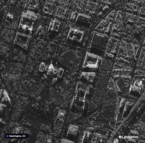


From what we can see in these previous images, the roughness of the surface determines how much it reflects back to the antenna. Water surface tend to be black because they are flat and don’t have any angle for backscatter. Wind create roughness on water surfaces, allowing some reflection back to the antenna. The images of buldings shows how angles and the edges create very bright returns, and these always are in the direction of the radar waves.
Different from IR vision and the normal daylight vision, the source of light in the radar images is the radar itself.
