- Yes
- No
Hello everyone and welcome to this new suggestion.
Today, for my 150th suggestion, I present to you a map, probably the one closest to my heart: the map of Brittany / Breizh.
Brittany is a region whose identity is deeply marked by its history, geography, and unique culture. Located at the westernmost tip of France, it forms a massive promontory into the Atlantic Ocean, bordered to the north by the English Channel and to the south by the Bay of Biscay. This geographical position has always given it a strategic role, both for maritime trade and for the defense of the French coast. Its highly indented coastline, made up of headlands, rocky points, and countless islands, offers both natural harbors and complex navigational areas, which has shaped both the character of its inhabitants and the development of its ports.
The Breton landscape is characterized by ancient massifs and granite hills, remnants of mountain ranges eroded over millennia. The Monts d’Arrée and the Armorican Massif bear witness to this deeply rooted geological past. The oceanic climate, for its part, brings mild winters, temperate summers, and a near-constant presence of winds from the open sea, which explains the dense vegetation and agricultural richness of the inland areas. Historically, these fertile lands allowed for the development of prosperous rural societies, while the coastal areas saw the birth of very strong maritime traditions.
Historically, Brittany was for a long time a distinct political entity. Celtic people and culture arrived there several centuries before our era, leaving a lasting imprint visible in the Breton language, legends, and numerous megalithic sites such as Carnac. The Middle Ages marked the emergence of the Duchy of Brittany, a regional power capable at times of rivaling the Kingdom of France. After a slow evolution of alliances and conflicts, the definitive union of Brittany with France was sealed in the 16th century, with the gradual integration of the duchy into the kingdom. From then on, Brittany remained a territory with a strong cultural identity, where traditions, Christian spirituality, and Celtic heritage intertwined.
At the beginning of the 20th century, Brittany already occupied a strategic military position due to its extensive coastline and the presence of major natural harbors such as Brest (one of the major historical ports of the French Navy), Lorient, and Saint-Malo. With the outbreak of the First World War, the region became an essential hinterland for the French war effort. Brest, in particular, played a crucial role in welcoming American troops from 1917 onward, its port being one of the main entry points for the expeditionary forces that came to support France. The Breton countryside, for its part, provided a large number of soldiers mobilized for the front, leaving behind villages deeply scarred by the losses.
During the Second World War, Brittany was a region of major importance to the German army, which quickly grasped the strategic value of controlling its ports. Lorient, Brest, and Saint-Nazaire became essential bases for the Kriegsmarine’s submarines, leading to the construction of gigantic concrete bunkers, still visible today. The region endured a harsh occupation, and the Breton Resistance played an active role, notably in sabotaging railway infrastructure and transmitting information to the Allies. Allied bombing raids targeting the submarine bases caused significant damage to the port cities, which were rebuilt after the war. It is worth noting that the inhabitants of the Île de Sein, off the west coast of Brittany, joined the Free French Forces en masse in London following General de Gaulle’s appeal, representing 25% of the French volunteers present there (even though the island had only 1,400 inhabitants at the time). General de Gaulle is said to have remarked, “The Île de Sein is therefore a quarter of France!” After 1945, Brittany remained a major military territory. The Île Longue naval base, near Brest, was chosen in the 1960s to host French nuclear-powered ballistic missile submarines, permanently establishing the region at the heart of France’s nuclear deterrent. Lorient, formerly a German submarine base, became a major French Navy base before being gradually repurposed from the 1990s onward. The region also hosts several army regiments, naval air units, and military schools, benefiting from its prime location for maritime training. Since the beginning of the 21st century, Brittany has continued to play a vital role in French defense strategy. Naval activity remains particularly important around Brest and Lorient, both in military terms and in the shipbuilding and maintenance industries. Part of the French fleet’s fleet, as well as ships belonging to foreign naval forces that are clients of Naval Group, are designed locally. Current missions encompass maritime surveillance, logistical support, and international operations. Thus, Brittany combines a rich military heritage with a strategic position that remains relevant today, making it a key region within the national defense apparatus.
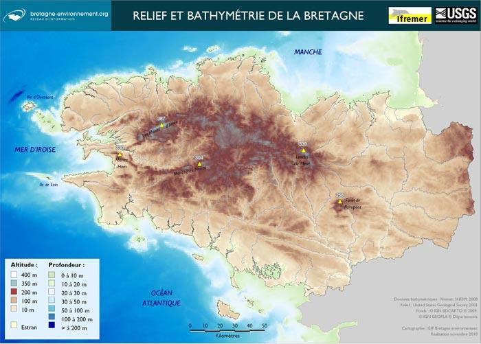
The map version I’m offering today includes all of Brittany, a region stretching over 250km from east to west and 150km wide at its widest point. This allows for a complete map of the region, making it an ideal terrain for battles in simulator mode, and more.
Why add Brittany to the game? As mentioned above, Brittany is an important part of France, having experienced war and possessing a significant military history. Its landscape is varied, combining plains, wooded hills, and small mountains.
Advantages:
- A historical battleground from World War II
- Varied landscapes
- The possibility of creating multiple maps within the same map, including new tank and naval battle maps.
Disadvantage:
- A very large map.