all the other maps are not still grey zones , and this is a problem of today all the maps are from 50 years ago and the are not the exact same locations
This does not have to be the exact same as well, just inspired by it. We have a Sinai map in the game, and that conflict was in 1973…
2 Likes
This would be an awesome air/ground map, I really like urban tank combat a lot!
1 Like
yea but Sinai is not a ghost town that still today citizens want there homes back, if you want an urban map we have a lot from Kabul to Chechnya, from Athens to Baghdad
Not to alarm you, the conflict ended in 1974. That is 51 Years ago.
Kursk has been involved in the Russo-Ukrainian War, and still is. European Province and Eastern Europe are both set in Ukraine aswell.
Famagusta is a massive place.
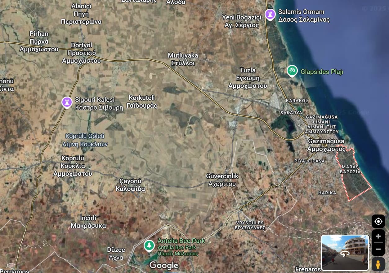
They can choose any place in Famagusta really.
Cyprus as a whole is a painful subject. That doesn’t stop people from suggesting it (eg in Greco-Iberian Tech Tree) or @Savage_Virus_R6’s other suggestions for Cypriot vehicles. I’m Turkish Cypriot, the fact the island is still split after 51 years hurts me aswell. Doesn’t mean we can’t get representation or see the island we love in the game.
2 Likes
Oh, Steep.
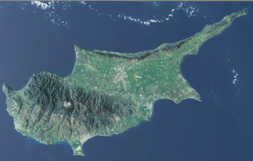
The terrain isn’t really steep or anything. Most of Famagusta is fairly flat, minus some slight hills. You can find topographic maps (both 3d and 2d) of the island, for reference.
3D Model from Birds eye view
3D View from perspective from in between Larnaca + Famagusta Bay
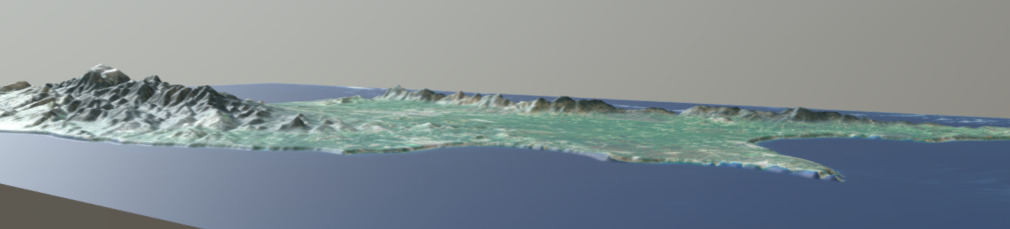
3D Model
2 Likes
its very deferent to put vehicles and real replicas of city’s the conflict didn’t end in 1974 the Kursk map the others are inspired by locations the are not the exact same and as i sad before if you want urban map the are thousands of citys
They will never be able to make the exact same Varosha anyway… It’s impossible.
If they do make it, it’ll look similar, but not exactly the same.
Whether Gaijin use Varosha/Maraş or the surrounding Famagusta District is up to them. They can take inspiration from villages (Tuzla, Alaniçi, Atılar/Aloda) or towns (Yeni İskele)- or just use Varosha. What happened on the Cypriot island is something that deserves to be represented in the game. For why would we allow D-Day to be in the game, and not Varosha?
Also this can be similar to the two Sinai maps, where one takes place in a massive open plain and the other takes place in a bit more Urban area.
1 Like
The terrain is not flat. in the Mesaoria area (the middle there are hills, they are going up and down the whole time, there are hill which spann 100+ from the ground and other 50 or 20 meters it depends on the area. In addition to that the middle of the island is ussaly 200-150 meters above sea level. and as you get closer to troodos mountain the terrain changes a lot. as for pentadaktylos mountain its different. Both have their own beauty. I agree that Varosssia map would be interesting, what about the old town of Nicosia and the sourounding area?
So, not Famagusta.
Also not Famagusta.
So again, not Famagusta.
Famagusta is a pretty flat area. I spend a lot of time there in the Summer, it is flat.
Yes, I am not talking about Famagusta/ Ammoxostos the City. You referred to the whole island, and you said its not steep or anything (meaning you literally have no idea of the topography of the island. you also said Larnaca, Larnaca has some ups and downs but not like the middle its still steeper than Ammoxostos City (not the whole district).
They can add the whole Island as a map for air and other Areas for Ground, some for smaller tiers other for bigger.
And why do keep referring to the surrounding villages/areas from non-recognized names.
They should definitely add Cyprus for Air Battles, as it is not larger than the Suez area (currently featured in the game).
In addition to Famagusta they could add the Old Nicosia International Airport as a Ground Map.
The problem with the old international Airport is the emptiness due to the runway. except if the make it a bit smaller, and fit the old weapons storage, then the houses that the UN (or British don’t remember) live with the old car factory, of course the nature which surrounds it then yeah, and on the background the pentadaktylos mountain and the city of Nicosia behind.
I’m not sure about the size of the Suez area, but yes, they should.
No I did not. Savage virus asked me what the terrain would be like (given I’ve spent tons of time in Famagusta). I literally sent a topographic 3D map that visibly has mountains everywhere else on the island. I said “Most of Famagusta is fairly flat” and never referred to the whole island in the slightest, only when talking about the map I sent (which IS a topographic map of the entirety of Cyprus)
The view from Larnaca Bay and Famagusta Bay as a reference for the Topography of Famagusta.
I’m Turkish Cypriot. The villages I refer to no longer go by Greek names so I use their Turkish names. I’ve been to Alaniçi, none of them refer to it as anything but Alaniçi as that name was used even before the Northern and Southern split. And since these villages now are only used by Turkish Cypriots, it’s only fair I call them by that name. I’ve only known them by that name as thats what the inhabitants have told me. For example, my family’s surname comes from our old Southern village’s name in Turkish as thats what we called it. The Greek Cypriots who lived with us back then (50-60~ odd years ago) called it by their own name.
If you are translating my messages, then it may cause errors. Other than that, I don’t see how you’re misinterpreting my messages other than the fact that you are being rude or stupid.
Since you said I have no knowledge of the Topography of Cyprus (despite going there every year and spending time in ALL districts), I assume you’re being rude.
Yes you typed Larnaca, and most of Famagusta is flat (and then the district, cause the district extends to pentadaktylos mountain.) And I replied for the map which you send.
No it not fair to call them by that name. I am not being rude, you are being rude by disregarding their real names. If it wasn’t a Turkish Cypriot village or didn’t have a different name then the name is Greek. I know that there are villages which names are Turkish and that’s how they should be called, we don’t change the names of the villages because we want to make it to our liking. Since are used by Turkish cypriots, pleaasee we dont change the names of your villages, we don’t disregard history and names like Turkey does.
You did not said you are going every year, you said ( I spent a lot of time in the Summer. ) (despite going there every year and spending time in ALL districts) have been to all districts really??? Did you go to the Non Occupied part of the island? have you seen leukosia District? Pafos? Limmasol? No you did not.
or Laranca? (The city itself is flat and when you go outside hills start to pop up.
You said about rudeness, you are rude when you refer to areas with Turkish names. The area names should not be changed in either area (occupied/ non-occupied) and the island did not Split it was invaded and then occupied.
We don’t. These villages have had their Turkish names called by the Turkish Cypriots long before Turkey invaded the island. As I said in my post, my people called it by its Turkish name in Turkish and its Greek name in Greek (BEFORE 1963/74).
…yes I have? I went to Ayia Napa, Mackenzie Beach, my old village in the South, Limasol,. Petra tou Romiou and come through Paphos/Pafos airport- where I spent a night in Axiothea Hotel. I remember seeing an Irish pub directly North of Paphos! I’ve spent time in Cyprus, believe it or not. I am Cypriot first and foremost, it’d be hypocritical if I had never been to the island.
Hence why I said mostly. mostly flat.
Because I’m talking about the most recent summer? I spent most of my time in Famagusta in the summer. I also went the summer before that, and before that, and before that and before that. I even went twice in 2019. The only reason I don’t spend more time there is because of military service.
LARNACA BAY, the view from LARNACA BAY.
OPEN
Θα υποθέσω ότι υπάρχουν πολλά μεταφραστικά λάθη, καθώς συνεχώς παρερμηνεύεις αυτά που λέω. Βρες έναν καλύτερο μεταφραστή ή μην προσπαθήσεις να μου μιλήσεις μέσω ενός, αφού προφανώς δεν λειτουργεί.
Θα σταματήσω να απαντώ τώρα επειδή είναι εκτός θέματος για το νήμα και αυτό δεν οδηγεί πουθενά.
Which country this place belongs to now?
The UN (Varosha), or officially The Republic of Cyprus.
Unofficially, the remaining inhabited city is under the control of the Turkish Republic of Northern Cyprus.
Interesting. I lived in Cyprus in 73/74 and was evacuated out when the fighting started. I believe that my old house has been demolished now in ‘no mans land’ in Nicosia.
Would be interesting to have a Cypriot map in Warthunder, not that i remember much of my time there!